United States Physical Map

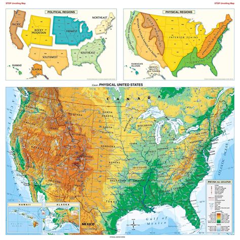
The United States physical map is a vital tool for understanding the country's diverse geography, which spans across North America. With its vast territories, the US encompasses a wide range of physical features, including mountains, rivers, deserts, and coastlines. The country's physical landscape has played a significant role in shaping its history, climate, and economy. In this article, we will delve into the various aspects of the US physical map, exploring its key features, regional characteristics, and the impact of its geography on the nation's development.
Key Points
- The United States is the third-largest country in the world, covering approximately 3.8 million square miles.
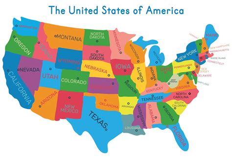
- The country's terrain is divided into several major regions, including the Pacific Coast, the Mountain West, the Great Plains, the Midwest, the Northeast, and the Southeast.
- The US is home to some of the world's most iconic mountain ranges, including the Rocky Mountains, the Appalachian Mountains, and the Sierra Nevada.
- The country's river systems, such as the Mississippi River, the Colorado River, and the Rio Grande, have played a crucial role in shaping its geography and economy.
- The US has a diverse range of climates, from the tropical beaches of Hawaii and Florida to the arctic tundras of Alaska.
Mountain Ranges and Peaks

The United States is home to some of the most impressive mountain ranges in the world. The Rocky Mountains, stretching from British Columbia, Canada, to New Mexico, are a prominent feature of the US physical map. The highest peak in the Rockies is Mount Elbert, located in Colorado, which stands at an elevation of 14,433 feet (4,399 meters) above sea level. The Appalachian Mountains, running along the eastern coast, are an older and more eroded range, with the highest peak being Mount Mitchell, North Carolina, at 6,684 feet (2,037 meters) above sea level.
Volcanic Regions and Landforms
The US is also home to several volcanic regions, including the Hawaiian Islands, the Pacific Northwest, and the Southwest. The Hawaiian Islands, located over 2,300 miles (3,700 kilometers) west of the North American continent, are a chain of volcanic islands, with the largest being the Big Island. The Pacific Northwest, which includes the states of Washington, Oregon, and Idaho, is home to several active and dormant volcanoes, including Mount St. Helens and Mount Rainier. The Southwest, which encompasses the states of Arizona, New Mexico, and Texas, features numerous volcanic landforms, such as the Four Corners region and the Rio Grande Rift.
| Mountain Range | Highest Peak | Elevation (ft) |
|---|---|---|
| Rocky Mountains | Mount Elbert | 14,433 |
| Appalachian Mountains | Mount Mitchell | 6,684 |
| Sierra Nevada | Mount Whitney | 14,505 |
| Cascade Range | Mount Rainier | 14,411 |

River Systems and Watersheds

The US has an extensive network of rivers, with over 250,000 miles (400,000 kilometers) of rivers and streams. The Mississippi River, one of the longest rivers in the world, flows through the heart of the country, stretching from Lake Itasca in Minnesota to the Gulf of Mexico. The Colorado River, which forms the border between Arizona and California, is a vital source of water and hydroelectric power for the region. The Rio Grande, which forms the border between the US and Mexico, is a significant river system, supporting agriculture, industry, and urban centers.
Coastal Regions and Shorelines
The US has a diverse range of coastal regions, from the tropical beaches of Hawaii and Florida to the rocky shores of Maine and Oregon. The Atlantic Coast, which stretches from Maine to Florida, features a mix of sandy beaches, barrier islands, and rocky headlands. The Gulf Coast, which includes the states of Texas, Louisiana, Mississippi, Alabama, and Florida, is known for its warm waters, white sandy beaches, and vibrant cities. The Pacific Coast, which runs along the states of California, Oregon, and Washington, is characterized by rugged shoreline, scenic beaches, and iconic cities like San Francisco and Seattle.
What is the longest river in the United States?
+The longest river in the United States is the Missouri River, which stretches for approximately 2,341 miles (3,767 kilometers) from its source in the Rocky Mountains to its confluence with the Mississippi River.
What is the highest peak in the United States?
+The highest peak in the United States is Denali (formerly known as Mount McKinley), located in Alaska, which stands at an elevation of 20,310 feet (6,190 meters) above sea level.
What is the largest desert in the United States?
+The largest desert in the United States is the Great Basin Desert, which covers an area of approximately 190,000 square miles (492,000 square kilometers) across Nevada, Oregon, California, Utah, and Arizona.
In conclusion, the United States physical map is a complex and diverse entity, reflecting the country’s rich geological history, varied climate, and unique geographical features. From the towering mountain ranges to the expansive river systems, and from the tropical beaches to the arctic tundras, the US physical map is a testament to the country’s incredible natural beauty and its importance in shaping the nation’s identity and development.


