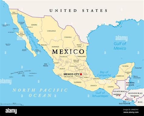
Mexico United States Map

The Mexico-United States map is a vital tool for understanding the geographical relationship between these two North American countries. Sharing the world's most crossed international border, the U.S.-Mexico border stretches for approximately 1,954 miles (3,145 kilometers), making it one of the longest international borders in the world. The map highlights the diverse landscapes, climates, and cultural influences that exist along this extensive boundary.
Key Points
- The U.S.-Mexico border is the most frequently crossed international border in the world, with over 350 million legal crossings annually.
- The Rio Grande forms a significant portion of the border, particularly in the eastern and central sections.
- Major cities along the border include San Diego, California, and Tijuana, Baja California; El Paso, Texas, and Ciudad Juárez, Chihuahua; and Laredo, Texas, and Nuevo Laredo, Tamaulipas.
- The border region is home to a diverse range of ecosystems, including deserts, mountains, and rivers, which support a wide variety of flora and fauna.
- Economic activities in the border region include manufacturing, agriculture, and tourism, with the North American Free Trade Agreement (NAFTA) and its successor, the United States-Mexico-Canada Agreement (USMCA), facilitating trade between the two countries.
Geographical Overview

The Mexico-United States border traverses a variety of landscapes, from the Sonoran Desert in the west to the Rio Grande in the east. The region’s geography has played a significant role in shaping the history, culture, and economy of both countries. The border is marked by a range of features, including the Rio Grande, which forms a natural boundary for approximately 1,255 miles (2,020 kilometers) of the border.
Border Regions and Cities
The U.S.-Mexico border is divided into several distinct regions, each with its own unique character and cultural influences. The California-Baja California border region is known for its desert landscapes and bustling cities like San Diego and Tijuana. The Arizona-Sonora border region is characterized by its rugged terrain and popular tourist destinations like Nogales and Lukeville. The Texas-Chihuahua and Texas-Coahuila border regions are marked by the Rio Grande and feature major cities like El Paso and Ciudad Juárez, as well as Laredo and Nuevo Laredo.
| Border Region | Major Cities | Notable Features |
|---|---|---|
| California-Baja California | San Diego, Tijuana | Desert landscapes, Pacific coastline |
| Arizona-Sonora | Nogales, Lukeville | Rugged terrain, popular tourist destinations |
| Texas-Chihuahua | El Paso, Ciudad Juárez | Rio Grande, major border crossings |
| Texas-Coahuila | Laredo, Nuevo Laredo | Rio Grande, significant trade and commerce |

Economic and Cultural Significance

The Mexico-United States border is a critical component of the economic and cultural relationship between the two countries. The border region is home to a diverse range of industries, including manufacturing, agriculture, and tourism, which support the livelihoods of millions of people. The North American Free Trade Agreement (NAFTA) and its successor, the United States-Mexico-Canada Agreement (USMCA), have facilitated trade between the two countries, with the border region playing a vital role in the exchange of goods and services.
Environmental Considerations
The U.S.-Mexico border region is characterized by a range of ecosystems, including deserts, mountains, and rivers, which support a wide variety of flora and fauna. However, the region also faces significant environmental challenges, including pollution, habitat destruction, and climate change. Efforts to protect and conserve the natural resources of the border region are essential for maintaining the health and biodiversity of the area.
What is the length of the U.S.-Mexico border?
+The U.S.-Mexico border is approximately 1,954 miles (3,145 kilometers) long.
What are the major cities along the U.S.-Mexico border?
+Major cities along the border include San Diego, California, and Tijuana, Baja California; El Paso, Texas, and Ciudad Juárez, Chihuahua; and Laredo, Texas, and Nuevo Laredo, Tamaulipas.
What is the economic significance of the U.S.-Mexico border region?
+The border region is home to a diverse range of industries, including manufacturing, agriculture, and tourism, which support the livelihoods of millions of people and facilitate significant trade between the two countries.


